The enormous, near-apocalyptic temblor off the coast of Honshu would have been surprisingly tame, had it not been for the tsunami. The main reason for the comparative lack of architectural damage from the earthquake itself has to do with lessons the Japanese had learned well from history.
The great Tokyo earthquake of 1923 nearly flattened the city, with a notable exception to the general devastation: Frank Lloyd Wright's Imperial Hotel. It stood intact, surrounded by the debris of neighboring structures.
 Since 1995's Great Hanshin earthquake in Kobe, the Japanese have implemented building codes and disaster plans designed to mitigate the inevitable destruction associated with the different kinds of earthquakes to which Japan is subject. The Kobe quake took place near a large population center, under the island itself, rather than offshore, so it didn't have to cope with a tsunami. Still, it wasn't as prepared as it could have been, and the human and economic impact was immense.
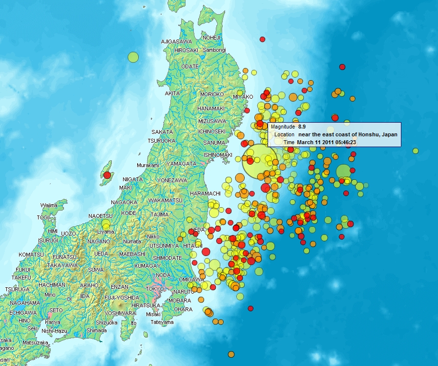
This week's quake was different, and the map below indicates why. It occurred along a subduction zone in relatively shallow water, not far from the coast: a recipe for large-scale tsunami impact. The numerous aftershocks haven't helped. I counted over 30 of magnitude 6 or higher on my iPad earthquake app--so many, in fact, that the big one had already dropped off the list. The pushpins on the map formed a huge, solid blob because the graphics weren't designed to depict hundreds of earthquakes. The map below is clearer, and if you click on it and then enlarge it, you can really see the enormity of an event that really hasn't stopped yet.
 Having lived in four major earthquake zones (Japan, Taiwan, the Owens River Valley, and southern California), I'm no stranger to the earthquake experience. Even when small ones occur in unlikely places (such as Pennsylvania and Dallas), I sense them early and seem like a prophet to those around me (or a complete nut; take your pick). My interest in geology may, in fact, have stemmed from wondering about what caused it all.
But the aftermaths are also indicative of how human beings respond to disasters when they live in areas prone to them. There are few places on the planet that aren't subject to some dangerous phenomenon or other. Here in North Texas, we're on the lower fringe of Tornado Alley (which seems to be widening as the climate changes), and always teetering on the brink of drought. Hurricanes, floods, katabatic winds, wildfires, avalanches, and all manner of catastrophic events occur in places that might be safe from earthquakes, volcanoes, and tsunamis--although many are located within areas with a wide variety of potential natural disasters to withstand.
How we live when faced with these consequences is where clear-thinking and lessons from history should prevail when making choices. Sometimes what seems to be a good idea at the time turns out to be problematic, as with Japan's increasing reliance on nuclear power. In order to reduce its dependence on oil, the country has chosen to bet on nukes. Now, to me this sounds absolutely crackers, given the location of the island: at the edge of a plate boundary subject to ten centimeters of movement in a year. Sure enough, the Guardian is reporting today that the Japanese nuclear industry has barely dodged a bullet at the Fukushima Daiichi nuclear reactor, and avoided a meltdown. At least for the time being.
 In 1872, what may have been California's worst earthquake in recorded history (around the same magnitude as the one in San Francisco in 1906) occurred along the fault line over which I was born. The valley's population then only numbered about 300, and twenty seven of them died. They're buried in a monument just outside of town. The land slipped down on the eastern segment of the fault, all the way up to Big Pine. On one of my last trips there before my father died, he pointed out the spot on the family's old property where a spring opened up as a result of the quake. (I love the lurid headlines at left; a sign of things to come in the Murdock era of tabloid journalism.)
 The adobe structure in the center crumbled, leaving only its roof.
 The frame house survived intact, losing only the flimsy shed attached.
The lesson from this rather small-scale local event (when compared, at least, with what Japan is going through today) was that adobe houses don't withstand earthquakes; only the frame houses survived. From then on, frame-built buildings took the place of adobe, which might be fine for fault-free Arizona and New Mexico, but clearly not the material of choice here.
On the other hand, the frame houses in Japan have never done well, probably because the quakes are different, the earthquakes bigger, the populations larger. But the effort to earthquake-proof buildings in Japan is focused on tall structures in business districts. Japan's real success has been in disaster-proofing its citizens, with drills and signs to direct them away from danger when possible. We can probably thank these measures for keeping the death toll down, even though it will probably keep climbing for a while.
I can't help but think that we'll never get it right if we don't stop pretending that our huge footprint on the planet doesn't make disasters worse. If we didn't rely so heavily on oil refineries, nuclear plants, and giant skyscrapers, and if we were spread about more wisely, might we not prevent much of the unnecessary suffering that attends our choices to live where danger is part of the landscape? If we didn't have huge energy grids susceptable to shutdowns due to weather or attack, wouldn't our energy needs be met more efficiently, without the potential for massive impact? If we weren't so very in love with using internal combustion engines to move us around unnecessarily long distances at ridiculous speeds, couldn't we vastly reduce the amount of dirty crap we spew into the air that, in turn, seems to be intensifying natural disasters?
Thinking smaller seems to make much more sense today than ever: more local food and energy sources, fewer commuter miles, more responsive local economies. I don't think for a minute that we'll ever decide to address any of these issues in any meaningful way, but when the latest disaster news takes over the wires, I can't help but long for a more thoughtful populace, and wiser political leadership.
Image credits: An old postcard view of the Imperial Hotel opens the post; it and the photo of the earthquake aftermath are from Wikimedia Commons. The map of what's now being called the Sendai Earthquake also comes from Wikimedia Commons. The shots of damage from the Lone Pine earthquake come from Susan Hough's report report on the event, "Owens Valley: Then and Now" on the USGS Pasadena pages.